Self hosting best practices
This feature is only available for clients who have a Public Works module and are incorporating GIS in their account. Please contact your Implementation Specialist or our Legendary Support Team if you are interested in utilizing GIS features in your account. Please use the following best practices to ensure a successful implementation of Asset Essentials with your GIS data hosted on your ArcServer. *Note: Please make sure you have SSL (https) configured on your ArcGIS Server. This is a requirement for integration with Asset Essentials. It insures a secure transfer of your user name and password, as well as your GIS information.
Database management
- Store all data in the same geodatabase, prior to publishing. The map document should be sourced to one geodatabase.
- Be sure to remove relationship classes, geometric networks, and tables from the geodatabase. *Note: Our solution does not recognize those database features, which could cause the data to display incorrectly.
Attribute fields
- Include a unique identifier field to associate work orders to GIS features:
- Asset Name *Note: This is required for Asset Essentials.
- Global ID *Note: This is required for Asset Essentials.
- Use field names that end users can easily identify.
- Field names and field aliases should match exactly.
Layer names
- Check to ensure there are no duplicate layer or group names.
- Be sure to use layer names that end users can easily identify.
- Always keep names concise.
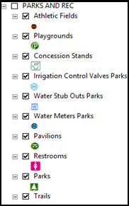
Grouped layers*
- Make sure group names are all capital letters.
- Group layers are based on the type of work and/or division.
- Be mindful of the drawing order when grouping. *Note: Grouping of layers is only allowed in ArcGIS Enterprise map services for use in Asset Essentials. You cannot include grouped layers in ArcGIS Online web map services for use in Asset Essentials.
Cartography
- Use Esri street map and satellite map to ensure data displays well against base maps.
- Remove Esri base maps prior to publishing data.
- Minimum scale ranges should be no less than 1:10,000, with the exception of Label scale ranges.
- Verify that labels are correct.
- Turn off all layers before publishing map service, unless there is base data that needs to be displayed across multiple sites.